3rd
Recon Association 2004 Reunion PX
817 Woodland Trail North
Bowie, TX 76230
Questions? Call (270) 821- 5700
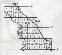
Map Locker
3rd
Recon Map Locker Color
Topographic Maps
I Corps: From the DMZ to South of Chu
Lai
Only
$6.75 Each Not all maps available from the map locker at this time.
Vietnam
Map, Series L7014 Series
DescriptionType:Topographic; multicolor Format:15' N-S by 15' E-W, Transverse Mercator
projection; 1,000 meter UTM Grid Symbols:DMA and Vietnamese Source: Photo-revised and format conversion
from stereo compiled 1:50,000 DMA Series
701
Characteristics:
Relief
shown by contours at 5, 10, and 20 meter intervals with 5 or 10
meter supplementary contours, at 25 meter intervals with 12.5 meter
supplementary contours, at 40 meter intervals and by form lines;
elevations in meters; foreshore and offshore detail shown; depths
in meters; drainage symbolized; standing water area indicated, international,
phan, and tinh boundaries. Provisional
Military Demarcation Line delineated; quan
boundaries delineated in Index to Boundaries south of 17', populated
places symbolized and classified by importance; roads classified
by weather ability, surface, and width; railroads classified by
gauge and number of tracks; airfields delineated and classified
by weather ability; vegetation symbolized,
trilingual marginal data (English, French, Vietnamese).
Following
is a table listing the DMA/NIMA/USGS Map number, map name, and comments
concerning features found on that particular map sheet. All of these
maps are in Series TL7014. They are 1:50,000 metric topographic
maps. Note that this listing is a work in progress and is far from
complete.We hope to be able
to expand the selection of maps offered for sale.The expansion is conditioned uponcustomer requests
for specific map locations to include other maps in I Corps, with
expansion , it is hoped, into II Corps, III Corps, etc.
Map
Locker
Map#
Stock
Number
Map
Name
Places
on this map
13
TL-7014-6342-1
Cam
Lo
DMZ,
Con Thien, Rockpile, Camp Carroll, Dong Ha Mountain,
Mutters Ridge, QL-9, Helicopter Valley,(XD, YD), Razor Back
14
TL-7014-6342-2
Thon
Doc Kinh
QL-9,
RT-556, Da Krong River, Song Quang Tri River, Laos-VN
border east of RT-9 & Khe Sanh (XD, YD)
Laos-VN
border, Da Krong River, A Luoi airstrip, Da Krong River
Valley (YD, QT)
28
TL-7014-6442-3
Ba
Long (Thon Ha Vung)
Quang
Tri (southern), QL-1, Son Thac Han River, Ba Long Valley,
Quang Tri City, RT-559, RT-557, RT-556 (Yd)
29
TL-7014-6442-4
Quang
Tri
Dong
Ha, Goi Linh, Cua Viet
30
TL-7014-6443-3
Vinh
Linh
Vinh
Linh, North Vietnam, RT-1A, Hon Co Island, DMZ (north),
Ben Hai River mouth, RT-1111 (YE, YD)
40
TL-7014-6541-2
Bach
Ma
West
of Da Nang, Bach Ma Mountain, Song Ku De River (w) Nui
Gai Tong, (YC, ZC)
41
TL-7014-6541-3
NongTruong
Nam
Dong
Nong
Truong Nam Dong, Roung Ruong, SFG (camp & airstrip)
A Shau (YC)
42
TL-7014-6541-4
Hue
Hue
City, Phu Bia, QL-1, Song Ta Trach River, Song Huong
River, (YD, YC)
44
TL-7014-6639-1
Tien
Phuoc
Tien
Phuoc, Phuoc An, RT-531, RT-533, RT-532, Tam Ky (BT,
BS)
48
TL-7014-6640-1
Hoi
An
Marble
Mountain, China Beach (south section), New China Beach
resort
50
TL-7014-6640-3
Hiep
Duc
Dai
Loc,Song
Tu Bon River (AT, BT)
51
TL-7014-6640-4
Dai
Loc
Hiep
Duc, An Hoa, Liberty Bridge, Hills 10, 25, 52, 55, 65
(Lt Reasoner area of operations), Charlie Ridge, Old
French Fort
53
TL-7014-6641-2
KhuNam
Pho, Tho
Monkey
Mountain, China Beach, Marble Mountain Airfield, RT
538, Da Nang RT 543, China Brach (north) (BT),
Khu Pho Nam Tho
54
TL-7014-6641-3
Da
Nang
Freedom
Hill, Hills 327, 34, 1st & 3rd
Mar Div HQTRs, Nam O Bridge, Hai Van Pass, Song Cu De
River Valley, Dong Den Mountain, Elephant Valley, Camp
Reasoner
59
TL-7014-6739-4
Ly
Tin
Ly
Tin, Chu Lai Airfield, QL-1, - (BT, BS)
60
TL-7014-6740-3
Tam
Key
Tam
Key (east), Chu Lai TAOR (south end of I Corps, BT)
All
profits from the sale of these maps will help support the 3rd Recon 2004 Reunion
fund raising activities and the 3rd
Recon Association;a
registered non-profit veterans group.Thank you for your support.