Team Somersail - One
 |
Team Somersail - One
|
3rd Force Recon
Company
Sgt. Jim E. Moshier, LCpl. James E. Kooi, LCpl. Michael W. Havranek, LCpl. John J. Foley, LCpl. Dennis R. Christie, Pfc. Charles D. Chomel, Pfc. James E. Widener
HMM 265
Maj. John S. Oldham, Capt. Curtis R. Bolscheid, LCpl. Jose J. Gonzales, Pfc
Thomas M. Hanratty
On 11 June 1967 a seven man Recon Team "Somersail-One" from 3rd Force left Dong Ha for an insertion LZ at YD 041681. This LZ was directly on the southern boundary of the DMZ . This area was four kilometers north of Hill 208 which was identified, during Operation Hastings in July 66, as the Division Command Post for the 324B NVA. and 900 meters west of Hill 174, another well known NVA position.
The Flight left Dong Ha at 1115hrs. A total of four Helicopters were involved. Two CH 46A's and two UH1E gunships. As the insertion helicopter was approaching the LZ it snapped up vertically and then rolled inverted tumbling end over end and crashed. It was seen spiraling out of control and the rear blades were seen separating. The helicopter crashed then burst into flames.
The bodies of the men lost were never recovered and they are listed today as KIA/BNR.
The
following account is provided by Eddie Delezen, a member of 3rd Force
at the time of the loss, and details his mission to visit the site where his
friends perished.
I returned to Vietnam again in May 2000. This was not my first visit since the war ended and hopefully won't be my last. Each visit is usually punctuated by one or two years of reflection aboard my sport fishing boat , "Osprey", in northwest Florida (AKA Emerald Coast ,or the Redneck Riviera). Through the years I have established strong friendships in Vietnam and now have a pretty good grasp on the language when written or if spoken slowly. During my prior visits, I have tried to reach the crash site of Somersail, a team from 3rd Force Recon Company that was lost on 11 June 1967. I was always turned back by police or soldiers because they are concerned about the vast amounts of unexploded ordinance in the area. I have learned that in present day Vietnam, getting off of the beaten track can be difficult. Tour companies have sprung up all over Vietnam that offer pretty much the same tour. Tourists are herded into Camp Carrol, Khe Sanh, the Cu Chi tunnels, shoot the AK, visit the war zones with lightening speed. Euro, Aussie and war veteran tourists see little of the culture or spend any time in the bush. It is very easy to visit the Rockpile, but to hike on to Mutters Ridge you have to avoid the tour companies. The problem is, if you get injured or become missing, the driver or guide or both will be charged and will lose their permit, which will break the family rice bowl. The permits are difficult to obtain. In order to travel into the bush, I travel with Vietnamese friends. They go into the bush to collect snakes and lizards for their snake wine and snake restaurant business. In order to have a profitable trip collecting, they must avoid checkpoints where police and soldiers demand bogus fees to enter areas. Corruption is everywhere in Vietnam. Tourists are often approached by people pretending to be officials and demand payment for visiting places like Khe Sanh, Camp Carrol etc. Just refuse and they will leave because if they get caught it is a serious crime (all crimes in Vietnam are considered serious). Khe Sanh has, in the last 2 years, established a little "tourist trap" museum that caters to Euro and Japanese tourists. They charge a fee (50,000 dong about $3.85)) to walk around the old base. Three years ago we could leave Khe Sanh and hike to hill 861 if we wanted to but now you are expected to remain around the old runway. Of course you can slip away and they won't come after you.
In order to visit the Somersail 1 crash site, I spent about a year preparing for the trip. First I read Marion Sturkey's book (Bonnie Sue) and got the actual insert position (YD 041681). I researched the crash and found out that the actual crash position (YD 048689) is a few hundred meters to the northeast from the intended insert position. During that period, I was in Spiceberry One, Sgt. Frank DeMoss was the team leader. We were in the bush when the crash occurred and we didnt find out about it until we returned to Dong Ha. It was always a mystery, no one talked about it and we heard all sorts of rumors. The area that the crash occurred in was a heavily defended area with bunkers and anti aircraft positions.
I contacted a good Vietnamese friend who owns a restraunt in Hue and asked for his help. He was worried about the mines and unexploded bombs in the area but agreed to help me reach the place if possible. We decided to begin our trek at Con Thien because in the last couple years few tourists have returned there. The area has become overgrown and is difficult to hike around. To make things worse, a farmer has been awarded the land to work and has been busy planting thorn trees to discourage tourists. Due to the lack of tourism at Con Thien, the party has lost interest because there are few tourists to charge fees. Fewer Americans are returning, Veterans arrived for a few years but now they trickle in. This past May, I only saw one American in Vietnam, this was in Da Nang and the guy sells health and life insurance to workers in Ha Noi, I am still laughing about that. The Veterans that will return have just about already returned. Sadly Con Thein is becoming a forgotten place. After we are gone no one will know what happened there. Perhaps the place will harbor Chinese troops when they arrive to claim the vast expances of rice, coal, oil, rubber, coffee, and deep water ports. I have to mention that Con Thien is the quietest place that I have ever visited, especially when camping there at night.
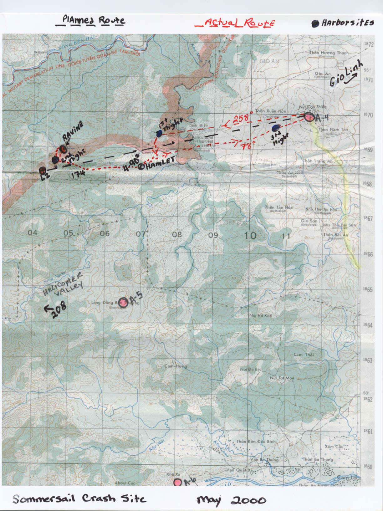
The Somersail crash site lies approximately 4.5 miles from Con Thien on an azimuth of 258 degrees magnetic. I still have the topo maps that we used 33 years ago and they are still extremely accurate. The villages are not the same but the topo is and that is what is important. Most hamlets now have communist names. Example, Khe Sanh is best referred to by the pre-American name, Huong Hoa. The prominent hill in the crash area is Hill 174. The site is about 3.5-4 km north of Helicopter Valley (Song Ngan Valley). At times while hiking toward the site, hill 174 is visible and the compass is not needed.
With my wife staying in Hue with friends, we left for Con Thien. My friend and his son carried their snake gathering sticks and bags to put them in. They were fascinated with the maps and contour intervals. Also they corrected the village names and marked spots where there are new villages and crossed out those that have been abandoned. We carried little food. Vietnamese refuse to eat anything that is not absolutely fresh. This eliminated the need to carry food because we would get what we wanted in the villages we passed through. However we did carry sweet rice and rice balls wrapped in banana leaves for the first day in the bush. We started out with 4 liters of water each but soon realized that bottled water was available in the villages, we were happy to shed the weight. We were able to drink from some flowing wells but when I showed them the water that Marines drank, they looked at me with disbelief.
The hike west was difficult due to the scrub brush and thorns. We tried to stay on trails that went in the direction we traveled. It was hot! I am a native Floridian and love hot weather but the heat at Con Thien is an entirely different animal as you all have experienced. We drank water constantly and each time we came across a hamlet, we bought more. Water costs 9000 dong per liter(13000 dong per 1 US Dollar). It was nice to not have to carry more than 2 liters of water at a time. My pack contained a first aid kit, K Bar knife, toothbrush, camera, beef jerky, chewing gum, a ground cloth to sleep in, rain jacket, and a long sleeved shirt. It was a great deal different that the previous days at Con Thien when we carried a rifle, 20 magazines, 12 frags, 9 canteens, 5 days food, claymore, battery, etc. etc etc.
We stopped for the first night just west of the Agricultural Development Center, you can make good time when you are not hiding or trying to be quiet. Arriving at dark we slept hard until 3 am. It rained during the night and everything was soaked. We started a fire with wet wood and ate the rice balls and made green tea. There were many animals in the area, snakes are a real problem now, unlike during the war years. As we travelled, my friend pulled Cobras and Kraits from their hiding spots and put them in the bags that hung from each end of a bamboo pole. He makes snakewine which is considered medicine in Asia. MDs prescribe it for many maladies. Does it work? I dont know but I enjoy drinking it. Also he serves Cobra in his restaurant.
After leaving the "harborsite", the bush became much thicker. A lot of wood gatherers began to share the trails with us and showed us snake lairs as we travelled. I was an odd attraction , an American that speaks Vietnamese so far from the tourist tract, I was the first American that most had ever seen. We passed through the "4 nineties" area. It felt strange to walk through the area making noise and staying on the trail. No helicopter noise, strange experience. It grew hotter, we stopped at a stream and went swimming to escape the heat. We plotted our position and decided to move south to a hamlet that is not on the map. When we arrived we ate fish soup, and drank a couple beers. With the snakes beginning to feel the heat and needing shade, we decided to leave them in the village and retrieve them on the way back. Hill 174 was visible from the hamlet so we moved for it. The brush was thick and the trails were becoming scarce and narrow. We arrived near hill 174 in the late afternoon. I decided to forget the LZ and move toward the ravine where the CH46 went down. By dusk we were on the gentle slope of elephant grass that must have been picked by Jim Moshier for his insert LZ.
I brought a Marine Emblem attached to a piece of stainless plate to leave as a marker. I only took 2 photos of the trek because after arriving it didnt seem appropriate. I am not a religious person so I was happy when my Vietnamese friends burned joss sticks and chanted Buddist prayers for the brave men of HMM 265 and the 3rd Force Recon Co. I buried the emblem where I felt confidant I can relocate it. I buried it because it will be taken if found. I hope to someday return to the spot and leave something more significant.
That night we stayed up late, the moon was near full and the elephant grass looked like the sea. I stared down into the dark ravine and felt the presence. It was a long night and as we sat around the fire we exchanged stories, which is the Vietnamese custom. MY guide broke out a bottle of rice wine and we drank to the Marines in the ravine. I drank the wine and enjoyed tales of Ong Ba Muoi (Mr. 30 Stripes), he was the tiger that defied authority and was beaten by the gos, their whips left 30 stripes on his back which tigers still carry. The fire died, and we slept and it did not rain.
We left the site at 4 am and hiked to the hamlet to retrieve the snakes and eat a late breakfast. By dark we were near Con Thien and exhausted from the heat, we decided to sleep and leave for Con Thien early. At 4 am we moved for Gio Linh and at first light flagged a ride on a truck that carried rubber grove workers. At Gio Linh we caught a quick ride to Dong Ha and immediately hitched a ride nonstop to Hue in an old Chinese dump truck. (Note; I dont advise anyone to try to hitch a ride with bags full of Cobras, Kraits and Bamboo Vipers, you will have to ride in the back of the truck).
In Hue, I climbed into the bath tub, my wife Kelly kept the cold beer coming. The water turned orange from the Con Thien dirt and the leech bites on my feet and ankles began to heal. The air conditioner was set on "cold" and all was well with the world.
It wasn't until I returned to Florida and my boat that I realized just how little I had accomplished. There was little that I could do except sit there and offer rice wine to my fallen comrades. I am not even sure how close I was to the actual site, I was probably within 100-200 meters. It is so thick and so vast, we forget how harsh the terrain is. In the end, I left a marker and let them know that they are not forgotten. Sadly there is still no closure for the families of those brave Marines.
Semper Fidelis,
Eddie DeLezen
Hue Vietnam May 2000
Text and map positions from notes kept on the trail.
Photo's
Map of area with route of march to the crash area.
Photo of Con Thien and Ravine where it is believed the crash occurred.